Integration of the Latest Spatial Technology in our Projects
A geographic information system (GIS) is a system that creates, manages, analyses and maps different types of data. GIS connects data to a map, integrating location data with all types of descriptive information. This provides a foundation for mapping and analysis that is used across many industries. GIS helps users understand patterns, relationships and geographic context and is known to improve communication, efficiency, management and decision making. With the ability to clearly visualise different types of data, users are able to uncover patterns, understand trends, monitor changes and respond to events.
Tredwell Management are highly experienced and qualified in utilising ArcGIS, which is a popular online GIS service developed and maintained by ERSI. Tredwell Management regularly use ArcGIS to undertake on-ground site audits and GPS mapping of trails as well as sport, recreation and open space facilities. ArcGIS allows for spatial data collection on a mobile device, which provides the ability to collect georeferenced attributes for each feature (e.g. surface type, trail signage, support infrastructure), a condition rating and georeferenced photographs. This best-practice auditing process allows for efficient workflows with data from the field to desktop refinements and visualisation of maps for inclusion in reports. These interactive maps and the associated GIS files can also be used during implementation of recommended initiatives and to aid in provision of information for trail managers and/or users.
Another important component of ArcGIS is the visualisation and subsequent analysis of various GIS datasets/layers to inform the opportunities and constraints of a project. The various GIS datasets/layers commonly used by Tredwell Management include public drinking water source areas, environmentally sensitive areas, Aboriginal Heritage Places, dieback infestation areas, mining leases, land tenure, land use, topography and other geographical features.
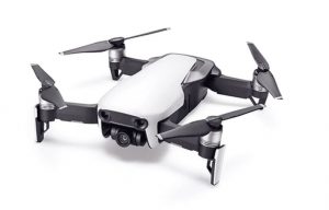
There are many other popular and contemporary spatial technologies that are used for data collection and analysis, such as drones. Tredwell Management have experience utilising the DJI Mavic Air Drone, which is portable and lightweight and allows for the collection of georeferenced aerial imagery and videography. The DJI Mavic Air Drone can be used for various functions such as site planning, design, auditing and analysis, collection of project data, 3D modelling of data and creation of videos for marketing and promotion. The integration of drones in field work is low cost, improves time efficiency and provides a better overall perspective of a site. The spectacular drone images of Point Lowly Lighthouse was provided by the City of Whyalla and used in the Whyalla Path & Trail Master Plan developed by Tredwell.

For further information on the spatial technologies we use in projects, or to incorporate drone imagery in your next project, please click on the ‘Contact Us’ button or call us for a chat Ph: (08) 8234 6387.

